
- Which stores are 5 miles or less from you?
- Which stores are 10 miles or less from you?
- Which stores are 15 miles or less from you?
- Which stores are 25 miles or less from you?
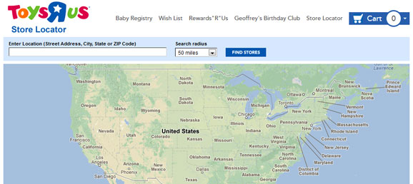
- Which stores are 50 miles or less from you?
- How does the Toys R Us store locator determine how far away a store is?
- What are ways of identifying a place’s location on Earth?
- How can we determine the distance between two places on Earth?
- What does that amount represent?
- Customer enters their location as “(Street Address, City, State or ZIP Code)”
- Customer enters a “Search radius” of 5, 10, 15, 25, 50, or more miles.
- The website converts the customer’s location into GPS coordinates in (x, y) format where x is the latitude and y is the longitude.
- The website looks at its database of store locations and finds their GPS coordinates, also in in (x, y) format where x is the latitude and y is the longitude.
- The website uses a formula (more on this later) to determine the distance between the GPS coordinates for the customer’s location and the store’s location.
- Any stores that are within the search radius (i.e, “less than 5 miles away”) are displayed to the customer
After discussing “The Situation” and “The Challenges”, the way I expect this lesson to go would be to pose the question “How does the Toys R Us store locator determine how far away a store is?” Students will probably say something like they take the two locations, look them up on a map, and find out how far apart they are. Have students explore how this would actually work and let them figure out what information they need as to where the customers and stores are located.
I imagine students will ask for the street addresses. However, unless the students have outstanding geographical knowledge of Phoenix, Arizona, the addresses by themselves should be useless to them without:
- a paper map (which I would not give them as computers can’t use paper maps)
- an online map (which I would also not give them as we are trying to discover how the store locator’s online map works rather than actually use them)
What we want students to realize is that GPS coordinates are the way to go. If students are not already suggesting that we use GPS coordinates, it would be a good time to ask them, “What are other ways of identifying a place’s location on Earth?”
Regarding GPS coordinates, they can be written in three basic forms. Wikipedia lists the forms as:
- Coordinate containing degrees (integer), minutes (integer), and seconds (integer, or real number) (DMS).
- Coordinate containing degrees (integer) and minutes (real number) (MinDec).
- Coordinate containing only degrees (real number) (DegDec).
We want to use option three so the coordinates contain “only degrees” in a form like (40.446195, -79.948862). If students wonder what the negative and positive values mean, they help define the Earth’s hemisphere (though the x and y values are swapped). A negative latitude (x-value) means the Southern Hemisphere while a positive latitude means the Northern Hemisphere. Similarly, a negative longitude means the Western Hemisphere while a positive longitude means the Eastern Hemisphere.
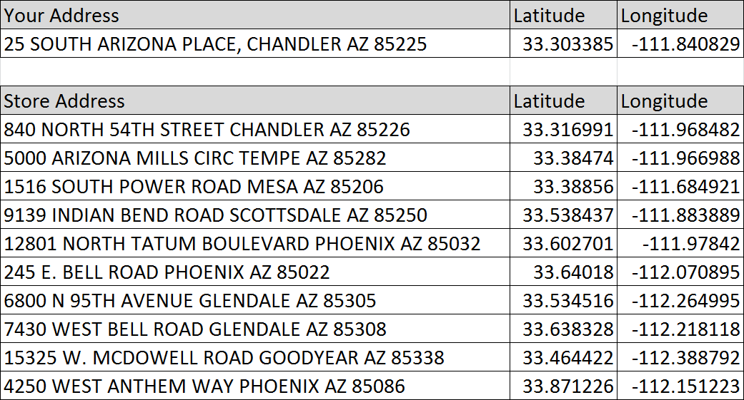
The screen shot below is from a spreadsheet included in the “Download files” link that has the shopper’s information and all of the stores’ GPS information. When they ask for the GPS information, this is what you can give them. I have mixed up the stores’ order so they are not listed from closest to farthest.
The next step is guiding them to realize how to find the distance between the GPS coordinates. Looking at the data and how the range between the GPS coordinates is less than one degree, students may believe that all of the stores are close together even though the street addresses are in different cities or zip codes. Eventually we want students to realize that the latitude and longitude, as an ordered pair, represent a point in a coordinate system and transition the conversation to how to find the distance between two points in a coordinate system. This is a great place to break from the problem, learn more about formulas to find the distance between points, and then return to the problem to apply the new knowledge.
Regarding the formula used to determine the distance between the points in a coordinate system, there are two options:
- The Pythagorean Theorem can be used to find the distances between two points in a coordinate system. This will provide a reasonably good approximation for how far apart they are and is what we use in this lesson. The problem comes from the fact that the Earth is not flat and that we are actually finding the distance between two points on a sphere.
- The Haversine formula is much more accurate and is what most websites actually use. However, it is beyond the scope of this lesson, being taught in spherical geometry, and is not a part of the Common Core State Standards. Technically the Earth is not a perfect sphere either but rather a spheroid, so this is also an approximation.
Once students have learned how to use the Pythagorean Theorem to find the distance between two points in a coordinate system, the next step is to find the distance between each of the stores and “Your Address”. Here is an example of how I would expect it to look:
Your address:
- 25 South Arizona Place, Chandler AZ 85225
- (33.303385, -111.840829)
Chandler Store:
- 940 North 54th Street Chandler AZ 85226
- (33.316991, -111.968482)
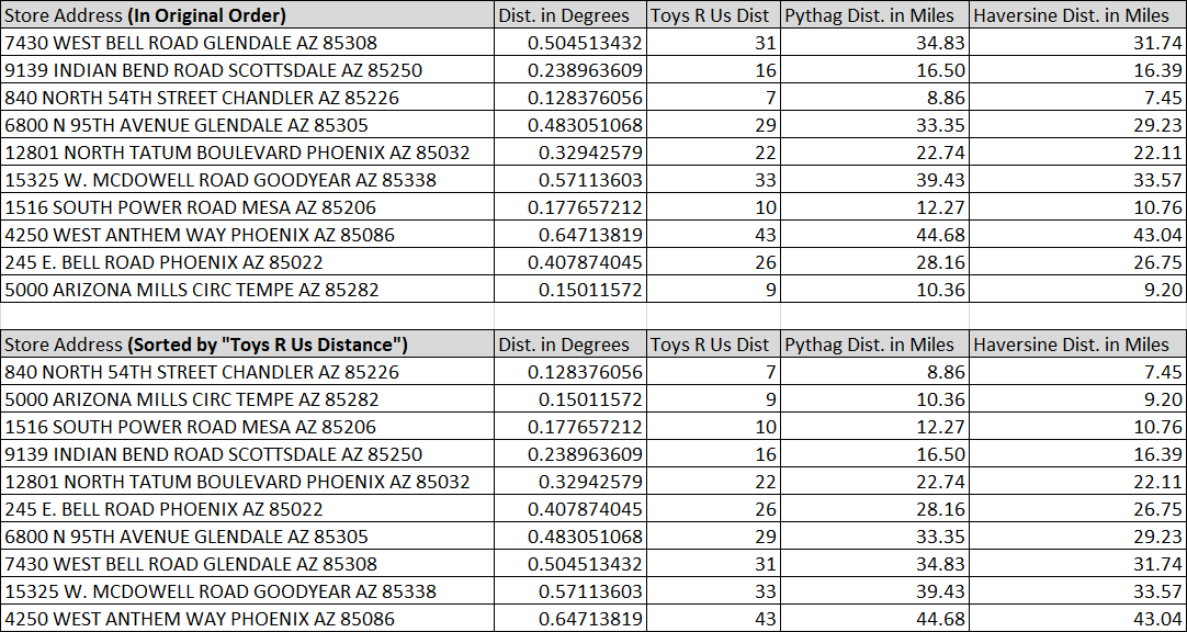
Distance = √( (33.303385 – 33.316991)² + (-111.840829 – -111.968482)² ) ≈ 0.128376055575013
Make sure to ask students to explain what that number represents. Students may have no context for what that number is. Is it the distance? If it is, what are the units? It is a great opportunity to practice both Math Practice 2 (“attending to the meaning of quantities, not just how to compute them” and Math Practice 6 (“they are careful about specifying units of measure”) amongst others. As it turns out, that is the distance between the two points measured in degrees. So the store is about 0.128 degrees away.
To answer “The Challenge” questions, students will need to convert it from degrees to miles by multiplying by 69.11 as each each degree is approximately 69.11 miles. As a result, students should end up with answers close to the ones in the “Pythag Dist. in Miles” in the table below (click the image for a larger size or download the spreadsheet):
With students having the distances in hand, have them list which stores should appear on the “Store Locator” search results page for 5, 10, 15, 25, and 50 miles or less away. Have them share what they expect to see on the actual search results page, then show it to them and discuss. Below are the actual search results from the Toys R Us Store Locator page along with my thoughts:
- 5 Mile Search Results – Page 1
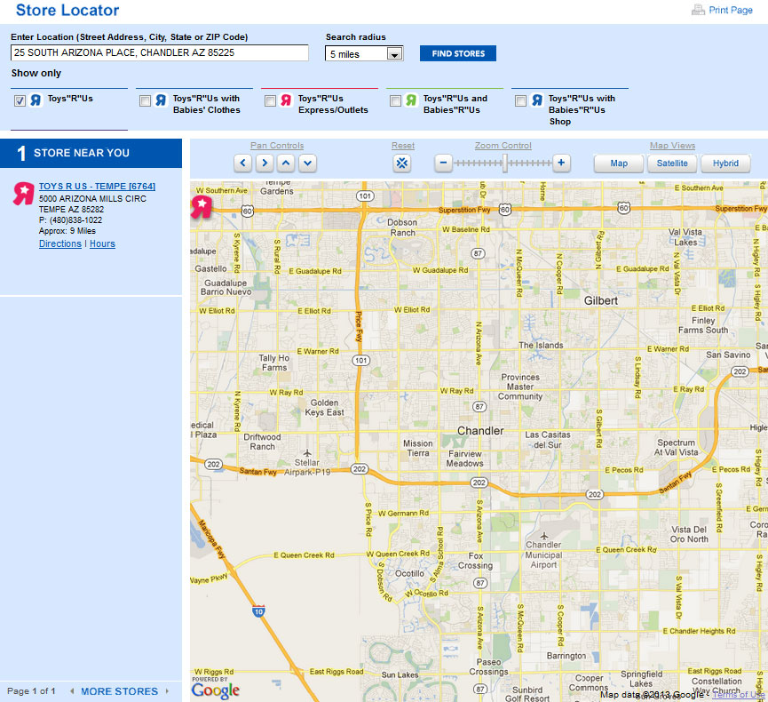
Students should expect no locations to be listed on this results page. However, one store is listed but is also listed as being “Approx: 9 Miles” away. It is worth discussing whether this should be listed. Perhaps the store wants to show at least one result at all times so they appear to have a local presence. However, as we will see on the next image, another store is closer, so this appears to be a mistake on their site.
- 10 Mile Search Results – Page 1
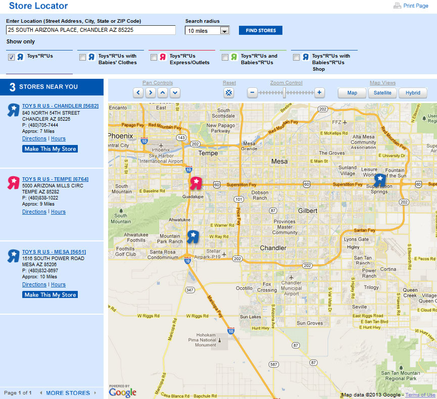
Students should have one or two of the stores listed on this page depending on how strictly they interpret 10.36 miles. Note that a new store has appeared that is 7 miles away. I can only guess that it is a mistake that prevented it from being displayed on the 5 mile page instead of the “9 Miles” store. Also notice that the Mesa, AZ store is the only one to be excluded from our list due to error from using the Pythagorean Theorem instead of the Haversine formula. Its distance is calculated at 12.27 miles instead of 10.76 miles.
- 15 Mile Search Results – Pages 1 and 2
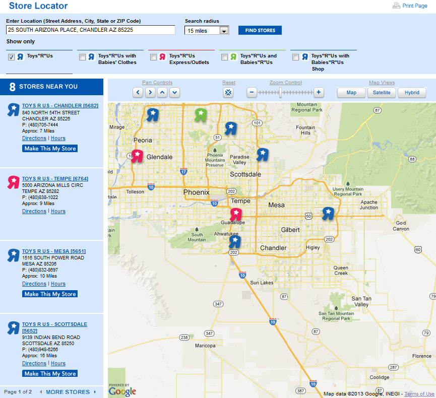

The mistakes on the Toys R Us website continue to grow. Using both the Pythagorean Theorem distance and the Haversine Formula distance measurements, only 3 stores are 15 miles or less from our location. Strangely, the website lists 8 stores of which the final 5 are all clearly listed as being farther than 15 miles away. This is a great opportunity to let students point out the mistakes, explain why they are wrong, and “critique the reasoning of others” (Math Practice 3). Students’ confidence in being smarter than a website should be growing here.
- 25 Mile Search Results – Pages 1 and 2

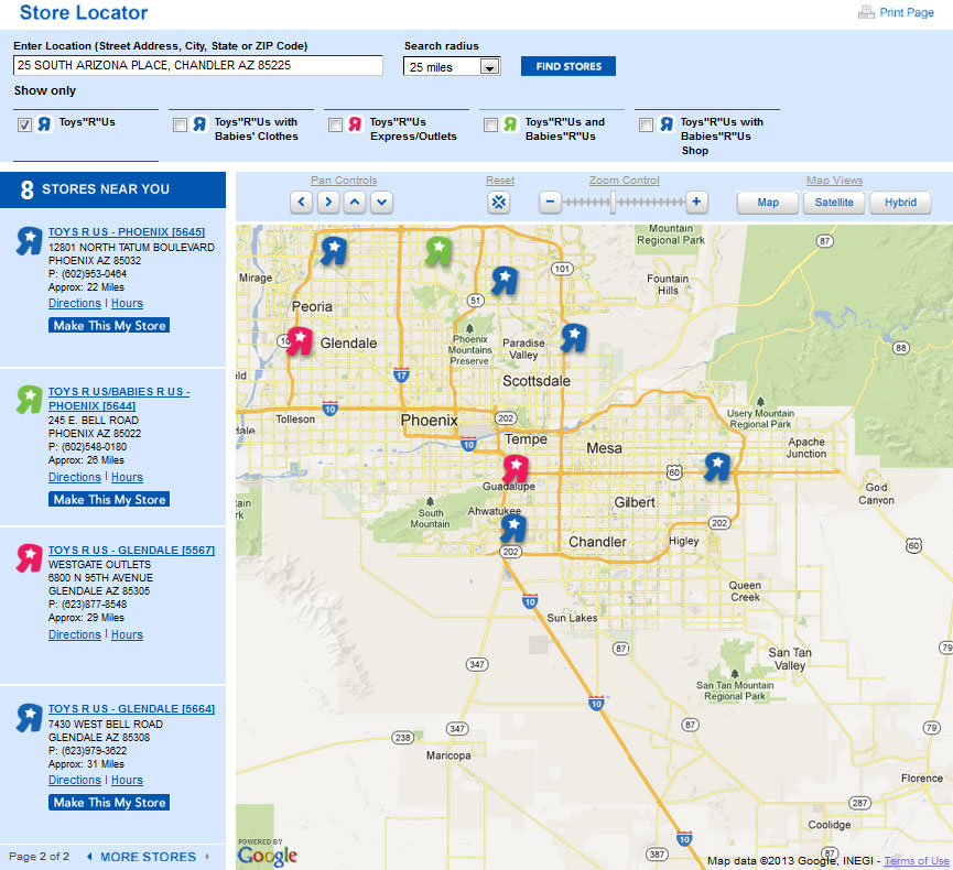
There are still mistakes with the results for 25 miles. Using both the Pythagorean Theorem distance and the Haversine Formula distance measurements, only 5 stores are 25 miles or less from our location. However the website still lists 8 stores of which the final 3 are all clearly listed as being farther than 25 miles away.
- 50 Mile Search Results – Pages 1, 2, and 3
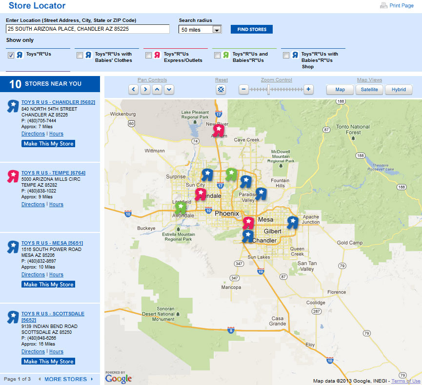
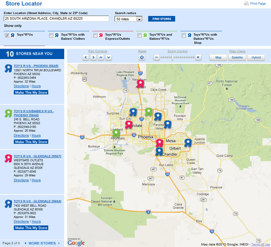
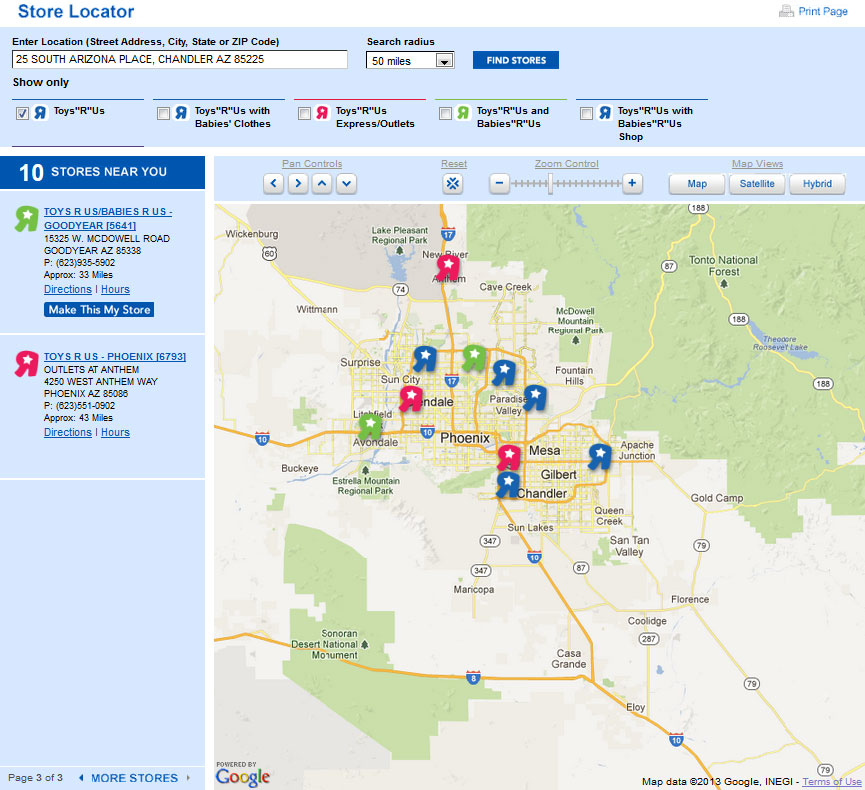
The website finally gets it right in the end. All 10 stores should be displayed in the list and they are.
- CCSS 8.G.8 Apply the Pythagorean Theorem to find the distance between two points in a coordinate system.
- CCSS G-SRT.8 Use trigonometric ratios and the Pythagorean Theorem to solve right triangles in applied problems.
- CCSS G-GPE.7 Use coordinates to compute perimeters of polygons and areas of triangles and rectangles, e.g., using the distance formula.
- Toys R Us
- Wikipedia – GPS Coordinates
- Wikipedia – Haversine Formula
- GPS Visualizer
- Scripts for calculating the distance between GPS coordinates